Publications
 Partners


The start of the weekend brings a chance of high fire danger as well as damaging interior winds in multiple regions across the country, according to the South African Weather Service.
Impact-based warnings
A Yellow Level 2 warning was issued for damaging interior winds, resulting in localised problems for high-sided vehicles on prone routes over the eastern parts of the Northern Cape and the extreme western parts of the Free State.
Fire danger warnings
Extremely high fire danger conditions are expected over the eastern parts of the Northern Cape, the north-eastern parts of the Western Cape, the extreme western parts of the Free State, and the northern parts of the Eastern Cape.
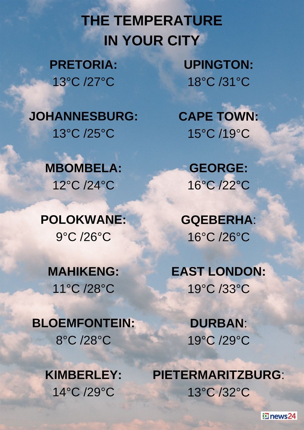
The weather in your region
Fine and warm conditions are forecast for Gauteng.
The expected UVB sunburn index is extreme.
Mpumalanga can expect morning fog patches over the Highveld and escarpment, otherwise it will be fine and cool to warm.
Partly cloudy conditions are expected in Limpopo's east in the morning, otherwise fine and warm temperatures are forecast.
The North West will be partly cloudy in the extreme east in the morning, otherwise fine and warm conditions are expected.
It will be windy in the extreme south-west.
Fine and warm conditions are expected for the Free State, becoming partly cloudy over the extreme south in the afternoon.
It will be windy in the west.
The Northern Cape can expect fine, windy and warm to hot temperatures, but it will be partly cloudy in the extreme west, where it will be cool.
The wind along the coast will be a light to moderate southerly to south-westerly in the afternoon.
Morning fog is forecast for the Western Cape along the west coast, otherwise it will be partly cloudy and cool to warm, with isolated to scattered showers and rain along the coast and adjacent interior.
It will be windy over the Central Karoo from late morning.
The wind along the coast will be a moderate to fresh northerly to north-westerly, reaching strong along the south-west coast in the afternoon.
The wind will be a light to moderate south-westerly, becoming light and variable by the evening east of Stillbaai.
The expected UVB sunburn index is moderate.
??Weather and ??severe weather alerts for today and tomorrow, 3 - 4 May 2024.#saws #weatheroutlook #southafricanweather pic.twitter.com/E08NUgQgGU
— SA Weather Service (@SAWeatherServic) May 3, 2024
The western half of the Eastern Cape can expect fine and hot to very hot temperatures, but partly cloudy and warm conditions along the coast, with morning fog and isolated evening showers and rain.
The wind along the coast will be a moderate to fresh south-westerly, reaching strong in places in the afternoon.
Fine and warm to hot conditions are forecast for the eastern half of the province, but it will be very hot in places over the interior.
It will be windy in places over the interior, becoming cloudy in the south-west in the evening.
The wind along the coast will be a light northerly, becoming a moderate north-easterly, but fresh south-westerly from the south in the evening.
KwaZulu-Natal can expect partly cloudy conditions in the east, with morning fog patches in places over the interior, otherwise it will be fine and warm to hot.
The wind along the coast will be a moderate to fresh northerly to north-easterly, reaching strong in places south of Richards Bay.
The expected UVB sunburn index is high.